Map projection aspect ratios
Question:
How can I get the right aspect ratio for a plot when I'm using
a map projection and a sub-global region?
Example:
Explanation:
Ferret's default aspect ratio is inappropriate for most plotsinvolving map projections. Especially when using sub-global regions,the aspect ratio of the plot needs to be adjusted so that gridcells in the plot that should be square actually are.
An additional map projection script, mp_aspect.jnl,is provided which calculates and sets the appropriate aspect ratio.It should be run after you have run the map projection script.
Note that if you are drawing map projection plots inside viewports, then mp_aspect.jnl should NOT be called. It may be skipped if you are satisfied with the aspect ratio of the particular viewport on the page, or use the script mp_viewpot_aspect.jnl to define a viewport with the correct aspect ratio for the plot. See the FAQ Map Projections in Viewports for more details.
Solution:
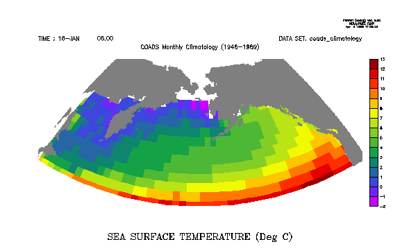
The example graphic above was created with the following commands:
yes? use coads_climatology
yes? set region/x=140:240/y=40:70/l=1
yes? set grid sst
yes? go mp_bonne
yes? go mp_aspect
yes? shade/noaxis sst, x_page, y_page
yes? go mp_fland 20
Note: You can also determine the aspect ratiowithout setting it:
yes? go mp_aspect 0
The appropriate aspect ratio is 0.45607