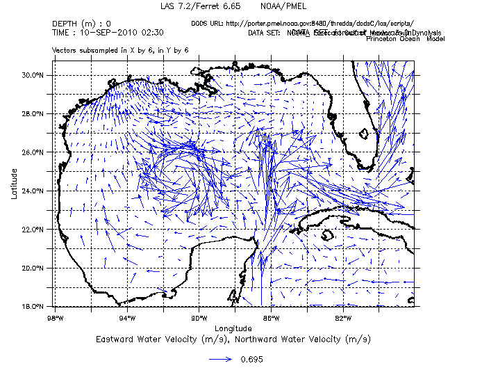
LAS can product many nice plot types associated with vector data.

In order to LAS to be able to make vector plots, it has two know which two (or three) variables are the scalar components of the vector. Often these related scalar variables are identifiable in the source data set by their names (taux and tauy, for example). AddXML attempts to find variables that follow an xyz or uvw naming convention for the scalar component and then groups them together as vector composites in the LAS configuration. It also adds attributes to the scalar components so they are plotted with a zero-centered palette so it's easy to spot the areas where the scalar is positive and where it is negative.
The following command and resulting configuration illustrates the automatic detection of vectors in a real data set.
Running this command:

addXML.sh -n http://data1.gfdl.noaa.gov:8380/thredds3/dodsC/dc_CM2.1_R1_Cntr-ITFblock_monthly_ocean_tripolar_01010101-02001231

produces configuration for LAS that groups uo, vo and wo together into a vector and sets up the centered palette for
plotting the individual components.

<datasets>
 <id-6015a156b2 name="GFDL CM2.1, Closed ITF Experiment"
 url="http://data1.gfdl.noaa.gov:8380/thredds3/dodsC/dc_CM2.1_R1_Cntr-ITFblock_monthly_ocean_tripolar_01010101-02001231">
 <composite>
 <uo-id-6015a156b2_vo-id-6015a156b2_wo-id-6015a156b2
 name="Vector of Grid_eastward Sea Water Velocity and Grid_northward Sea Water Velocity and Upward Sea Water Velocity"
 units="m s-1">
 <properties>
 <ui>
 <default>file:ui.xml#VecVariable</default>
 </ui>
 </properties>
 <link match="../../variables/uo-id-6015a156b2" />
 <link match="../../variables/vo-id-6015a156b2" />
 <link match="../../variables/wo-id-6015a156b2" />
 </uo-id-6015a156b2_vo-id-6015a156b2_wo-id-6015a156b2>
 </composite>

...

 <uo-id-6015a156b2 name="Grid_eastward Sea Water Velocity" units="m s-1" url="#uo">
 <link match="/lasdata/grids/grid-lon-lat-depth-time-id-6015a156b2" />
 <properties>
 <ferret>
 <fill_levels>c</fill_levels>
 <palette>light_centered</palette>
 </ferret>
 </properties>
 </uo-id-6015a156b2>
 <vo-id-6015a156b2 name="Grid_northward Sea Water Velocity" units="m s-1" url="#vo">
 <link match="/lasdata/grids/grid-lon-lat-depth-time-id-6015a156b2" />
 <properties>
 <ferret>
 <fill_levels>c</fill_levels>
 <palette>light_centered</palette>
 </ferret>
 </properties>
 </vo-id-6015a156b2>
 <wo-id-6015a156b2 name="Upward Sea Water Velocity" units="m s-1" url="#wo">
 <link match="/lasdata/grids/grid-lon-lat-depth-time-id-6015a156b2" />
 <properties>
 <ferret>
 <fill_levels>c</fill_levels>
 <palette>light_centered</palette>
 </ferret>
 </properties>
 </wo-id-6015a156b2>
N.B. each vector must appear in it's own set of composite tags.


